Geology and Ore Deposits of the Bawdwin Mines
This episode is the continuation of the previous episode 35 and describes significant points on the structure and ore bodies of Bawdwin Mines.
Structure
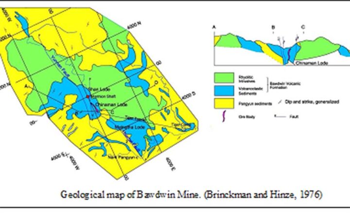
The Chaung Magyi highlands in the west formed an old land surface on which the succeeding Palaeozoic formations were laid down. The general strike of these is from north to south or north-north-west to south-south-east, with a prevailing easterly.
The most important structural feature of the district is the continuation of the great Lilu overthrust, one branch of which runs in a north-north-westerly direction and separates the western band of the Nam Hsim sandstones from the Pangyun beds. Indeed, the effects of the great fault are not so marked here as they are further south, and it probably dies out completely a few miles further north where it enters the Chaung Magyi rocks. The other branch of the fault passes close to the eastern boundary of the ore channel and continues south across the Pangyun and Nam Kung valleys to meet the former south of the Nam Tu-Nam Hsan road. Its exact line has not been mapped, but its effects are very evident in the intense crushing and dislocation of the strata. To the north, the Bawdwin branch of the fault seems to pass close to Lao-ka-ya and then continue north along the valley of the Nam It. “The cause of such a dislocation having taken place along this particular line is perhaps to be found in the existence, only a short distance to the west, of the unyielding mass of the older Chaung Magyi rocks, forming the old land of Taungpeng” (La Touche).
Ore Bodies
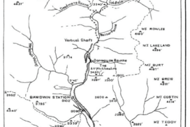
The ore bodies at Bawdwin are all confined within a well-marked zone or ore channel, except the subsidiary Goldhole ore deposit, which seems to lie on another line but on which sufficient exploratory work has not been done to enable its true relationships to be decided. The main ore channel is at least 8,000 feet long and is probably 400-500 feet wide. As Maclaren has already pointed out in his manuscript report, the northern limit of the channel ceased at the Goldhole Fault, not because it has heaved it (for the fault was formed before ore deposition), but because it threw rhyolite across the track of the fault zone in which the ore was developed. The fault certainly continues through the rhyolite, as is proved by the veins of quartz and barytes that traverse it, but no ore replacement took place. This was entirely confined to the tuffs. The ore channel is probably connected with the main line of faulting mentioned earlier, where crushing has been of a most intense description, and the shear planes and fissures thus produced have afforded easy passage to the mineralizing solutions which have replaced the original country rock, wherever this has been congenial. The ore channel plunges to the south at a shallow angle, passing a short distance below the level of the old Chinese adit level (171 feet below the collar of the vertical shaft at 3,600 feet south of the vertical shaft); it is capped by the Pangyun beds for a part of its extension towards the south but is exposed at its uppermost limit in the deep S. gorge, to the south of which it certainly disappears beneath the thick covering of the Pangyun Series above it. Along the whole of these 8,000 feet and still further south, as far as the tuffs extend, though this is an unknown distance at present, ore bodies can be reasonably expected. So far as we know, the ancient Chinese miners worked the upper part of the ore channel at its northern and fairly effectively for some 3,000 feet. Maclaron regards their adits to the south of this as opening up flat ore floors or small extent, which he supposes will occur sporadically in the lower felspathic beds of the Pangyun series.
Within the ore-channel the following lodes have been discovered:
(1) A western lode, the Burman in the vertical shaft section (perhaps represented further south by the Maingtha lode), and the Chinese ore body in the Amphitheatre section. These two lodes are very different in character, the former being a thin regular vein of lead-silver-zinc ore and the latter an enormous replacement deposit of zinc-lead-silver ore;
(2) a central lode, the Shan-Palaung, which parallels the Burman in the vertical shaft section about 150 feet further east;
(3) an eastern lode, indicated by the workings in the Jail and upper Dormouse ravines.
Only the Burman, Shan, and Chinaman lodes have been opened up; the presence of the others is mainly deduced from open-cuts or old workings. Their inter-relations are at present unknown and will remain so until the Amphitheatre and vertical shaft sections of the mine are joined at deep levels. The most reasonable hypothesis at present is to regard them as members of one system, perhaps continuous lodes, probably separately blocked out by cross-faulting. Another theory regards the lodes in the vertical shaft section as originating from the lenticular splitting of the Chinaman ore body to the north.
The Chinaman ore body is by far the largest and most important deposit yet discovered at Bawdwin, and I shall therefore describe it first. It has been explored by three levels, the zero level, 102-foot level, and the 171-foot level, by diamond drill bore-holes and by an internal shaft.
The Zero Level: The drives and crosscuts on this level encountered old filled Chinese stopes. Some copper ores occur in it associated with the zinc blende and galena. The level is very hot, the high temperature being due to the oxidation of the sulphides and the decay of the timber sots’ loft by the Chinese. Two rises, which are 100 and 128 feet high, respectively, go from it to the Amphitheatre, passing mainly through old fill.
The 102-foot level: The 102-foot level, also known as the Drainage tunnel, is largely in Chinese workings, the low-grade ore and old fillings of which are said to average 12 oz. silver, 16.3 per cent lead, and 20 per cent zinc. However, south of the crosscut of 1,120 feet, there are indications of the development of a zinc-lead core to the ore body, as seen on the 171-foot level below.
The 171-foot level or Dead Chinaman Tunnel: The portal of the tunnel is situated at 3,650 feet south and 50 feet west of the vertical shaft. It enters the ore channel at a point 1,887 feet south of the shaft and a horizontal about the same as the 171-foot level at the shaft and is driven right along the strike of the ore body, nearly to the Sau-Ch’uan fault, about 450 feet south, etc. It possesses a core of high-grade zinc-lead ore extending from about 1,730 feet south to 1,100 feet south, varying from 10 to 100 feet approximately in thickness. Outside this on the east is a zone of lead-zinc ore extending from 1830 feet south to 700 feet south, etc.
There is a perfect gradation from one ore to the other, and the boundaries are arbitrary and determined entirely by assay. The following are taken as type assays: –
The Internal Shaft: The internal shaft is sunk from the 171-foot level at coordinates 1,505 feet south and 175 feet east. Several crosscuts have been put out, which show the average values from zero to 126 feet to be silver 15.8 ounces, lead 20 per cent, and zinc 24.6 per cent. The average value of the crosscuts at 67 feet and 124 feet down is silver 18.4 oz., lead 21.3 per cent, and zinc 24.0 per cent over a width of 90 feet. By the end of 1915, the shaft had reached a depth of 446 feet below the Dead Chinaman Tunnel. When I examined the shaft in May 1915, it was being sunk through practically pure sulphides. Much of the argentiferous ore assayed from 40 to 50 ounces of silver and 40 to 50 per cent lead. Main levels leave the shaft at 300 feet and 430 feet. The Chinaman ore body is a great replacement deposit that occurs on the hanging-wall side of the ore channel. The axis of the thickest part of the sulphide core strikes approximately 25°west of the north and has a dip of 70°-80° to the west. At the time of my inspection, it had been proved to be a depth of 259 feet below the level of the Dead Chinaman Tunnel, but later it was found much deeper.
The Burma lode: It is thin but persistent in depth so far. It crops out near the Ssu-Ch’uan fault as a series of small parallel stringers of ore. The country around it and the Shan lode are badly faulty, and its true direction is not easy to follow in the present stage of development. On the 102-foot level, this lode was intersected by no.1 crosscut 50 feet from the shaft. It had improved both in width of stringers and quartz, and the 9-inch vein assayed 15.55 per cent load, 9 ounces silver, and 27.85 per cent zinc. On the 300-foot level, the Burman lode over a length of 190 feet shows an average width of 31 inches of lead-zinc ore, assaying 33 per cent lead, 37 ounces silver, 16 per cent zinc, and a trace of copper.
The Palaung lode: It was first worked as an open-cut between the Jail and Dormouse ravines. In 1909, an attempt was made to crosscut its continuation using a winze sunk from the Sulphide Tunnel, but the old Chinese drives, which were full of water, were encountered and caused much trouble. What was probably the continuation of this lode in depth was met with an east crosscut 800 feet south on the Drainage Tunnel at the 102-foot level. It was first encountered at 254 feet in and was only two feet wide but carried good copper and silver values. It was driven on for 28 feet, and samples over a width of 27 inches gave silver 15 ounces of copper 2.7 per cent, lead 9.7 per cent, and zinc 11.4 per cent.
The Dormouse lode: It was first noticed in the Dormouse Ravine. Its probable continuation in depth was encountered in the same crosscut from the Drainage Tunnel as the one that displayed the Palaung lode described above. At 327 feet, a thickness of over 5 feet of ore was passed through, from which two samples assayed silver 9.3 ounces, lead 7.5 per cent, and zinc 37 per cent. The name Kachin lode is given to a small copper vein that can only be seen in the vertical section.
The Goldhole ore-body: This is an independent ore-body that does not appear to belong to the Bawdwin ore-channel series. It lies 2,000 feet north of the vertical shaft, and the ore from it was used at one time as a flux to smelt the Chinese slags. It seems to be a thin, flat-bedded pyrite deposit containing some chalcopyrite and small quantities of chalcocite. It probably strikes north-north-west and south-south-east and dips at a low angle to the west. Near the surface, it is changed to a ferruginous gossan, which has been proven to contain small quantities of gold and native silver. The deposit seems to have been formed near the junction of two faults, but I was unable to establish its exact relation to them in the absence of extensive workings. It has been opened up by a drainage adit, but until the north drive of this has been continued through and beyond the ore, I cannot say more about it. A series of winzes from the adit would reach the ore at shallow depths, and its exploration should not be a difficult matter. The deposit contains copper, which is confirmed by the thick growths of copper sulphate crystals on the adit walls and roof and by the replacement of the rails with copper since the level was abandoned.
Faults
The faults may be divided into two groups: those before ore deposition and those that took place afterwards. Maclaren regards the ore channel as bounded by two main faults, which are approximately parallel and 500 feet apart. The north-easterly member forming the boundary between the rhyolites and his felspathic grit series (the tuffs of the present classification), is termed the Boundary Fault, and its apparent dip is south-west at about 80°. He regards the evidence for the existence of this fault as fairly clear, a conclusion with which I agree. Arguing from the discordant dips of the thin-bedded Pangyun beds, he assumes that the ore channel is bounded on the west by another called the Central Fault. Still, I am more inclined to agree with his alternative assumption that the zone in which ore deposition has taken place has been the scene of several parallel, though not necessarily continuous, movements developed by one long-continued uplift along the main line of weakness.
This has resulted in a shattering of the rocks, thus rendering them permeable to the ore-bearing solutions from below, and the deposition of their lode along the main planes of movement when these happened to lie in the rhyolite tuffs. In other places, no impregnation of minerals has taken place, and the faulted zone is barren. The main zone passes to the south through the S Gorge west of Tiger Tunnel.
References:
Brown Coggin J, 1917: Geology and Ore Deposits of the Bawdwin Mines, Records of the Geological Survey of India, Vol XLVIII, Part 3.

